Welcome to Sundarban

The Sundarbans is the largest single block of tidal halophytic mangrove forest in the world. The Sunderbans is a UNESCO World Heritage Site covering parts of Bangladesh and India.
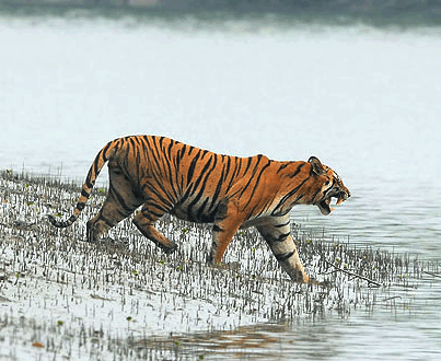
Two-third of the Sundarbans is in Bangladesh while rest one-third is in India. The Sundarbans National Park is a National Park, Tiger Reserve, and a Biosphere Reserve located in the Sundarbans delta in the Indian state of West Bengal. Sundarbans South, East and West are three protected forests in Bangladesh. This region is densely covered by mangrove forests, and is one of the largest reserves for the Bengal tiger.
History of Sundarban
The history of the area can be traced back to 200–300 AD. A ruin of a city built by Chand Sadagar has been found in the Baghmara Forest Block. During the Mughal period, the Mughal Kings leased the forests of the Sundarbans to nearby residents. Many criminals took refuge in the Sundarbans from the advancing armies of Emperor Akbar. Many have been known to be attacked by Tigers Many of the buildings which were built by them later fell to hands of Portuguese pirates, salt smugglers and dacoits in the 17th century. Evidence of the fact can be traced from the ruins at Netidhopani and other places scattered all over Sundarbans. The legal status of the forests underwent a series of changes, including the distinction of being the first mangrove forest in the world to be brought under scientific management. The area was mapped first in Persian, by the Surveyor General as early as 1764 following soon after proprietary rights were confiscated from the Mughal Emperor Alamgir II by the British East India Company in 1757. As the British had no expertise or adaptation experience in mangrove forests. Systematic management of this forest tract started in the 1860s after the establishment of a Forest Department in the Province of Bengal, in British India. The management was entirely designed to extract whatever treasures were available, but labor and lower management mostly were staffed by locals.
Geographical Importance of Sundarban
The Sundarban forest lies in the vast delta on the Bay of Bengal formed by the super confluence of the Padma, Brahmaputra and Meghna rivers across southern Bangladesh. The seasonally flooded Sundarbans freshwater swamp forests lie inland from the mangrove forests on the coastal fringe. The forest covers 10,000 km2. of which about 6,000 are in Bangladesh. It became inscribed as a UNESCO world heritage site in 1997. The Sundarbans is estimated to be about 4,110 km², of which about 1,700 km² is occupied by waterbodies in the forms of river, canals and creeks of width varying from a few meters to several kilometers.
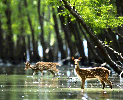
The Sundarbans is intersected by a complex network of tidal waterways, mudflats and small islands of salt-tolerant mangrove forests. The interconnected network of waterways makes almost every corner of the forest accessible by boat. The area is known for the eponymous Royal Bengal Tiger (Panthera tigris tigris), as well as numerous fauna including species of birds, spotted deer, crocodiles and snakes. The fertile soils of the delta have been subject to intensive human use for centuries, and the ecoregion has been mostly converted to intensive agriculture, with few enclaves of forest remaining. The remaining forests, taken together with the Sundarbans mangroves, are important habitat for the endangered tiger. Additionally, the Sundarbans serves a crucial function as a protective barrier for the millions of inhabitants in and around Khulna and Mongla against the floods that result from the cyclones. The Sundarbans has also been enlisted among the finalists in the New7Wonders of Nature.